Table of Contents >> Show >> Hide
- The Discovery Is Bigger Than the Headline
- Why Los Abuelos, Petnal, and Cambrayal Matter So Much
- Lidar Is Changing the Game
- Valeriana Proved the Jungle Is Still Full of Surprises
- What These Finds Change About the Maya
- Why Archaeologists Keep Finding “New” Maya Cities
- Experience the Discovery: What This Story Feels Like Beyond the Dig Site
- Conclusion
- SEO Tags
For years, the jungle kept one of the greatest tricks in archaeology hidden under a green blanket thick enough to humble drones, satellites, and probably your weekend hiking plans. Now that blanket is being peeled back. And what archaeologists are finding is not some lonely pyramid poking above the trees like a stone periscope. It is something much bigger, much messier, and much more exciting: a sprawling Maya urban world that keeps getting larger every time new technology and old-fashioned digging team up.
The headline says a massive Maya city is being unearthed, and that is true. But the real story is even better. Recent work in Guatemala’s Petén region points to a three-site urban complex centered on Los Abuelos, Petnal, and Cambrayal, with ceremonial, political, and engineering features that date back nearly 3,000 years. Meanwhile, in Mexico, lidar mapping helped researchers identify Valeriana, a large Maya urban center hidden in plain sight under forest cover. Put those finds together, and one message becomes impossible to ignore: the Maya world was not a scattering of isolated temples surrounded by empty wilderness. It was planned, connected, populated, and astonishingly sophisticated.
In other words, archaeologists are not just unearthing a city. They are unearthing a correction. A very large, very stone-built, very overdue correction.
The Discovery Is Bigger Than the Headline
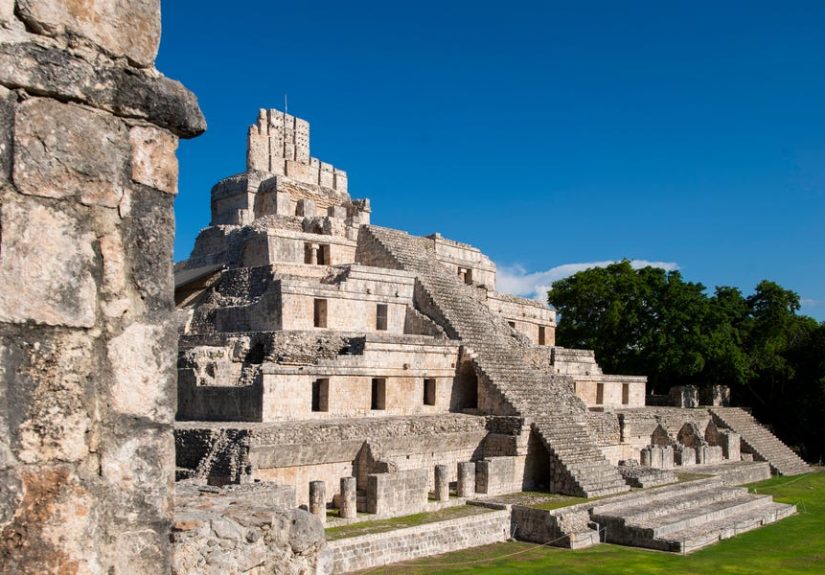
The most eye-catching recent discovery comes from northern Guatemala, near the already famous site of Uaxactún. There, archaeologists working in the Petén jungle identified a previously unknown urban triangle made up of Los Abuelos, Petnal, and Cambrayal. The complex dates to the Middle Preclassic period, roughly 800 to 500 B.C., making it one of the oldest and most important ceremonial centers yet identified in the Maya region.
That timeline matters. For a long time, the early Maya were sometimes described in simplified terms, as if serious urban planning showed up later with all the confidence of a teenager suddenly discovering architecture. But this discovery suggests that major ceremonial and civic organization was already taking shape far earlier than many casual readers might expect. These were not experimental villages with a nice view. These were purpose-built places with symbolism, infrastructure, and social organization.
Los Abuelos, whose name means “The Grandparents,” got its modern title from two human-like sculptures interpreted as an ancestral couple. That alone would make the site memorable. But archaeologists also found evidence that the place had ritual significance, including burials, offerings, and remains that suggest ceremonial activity. Some reports describe an astronomical complex or observatory there as well, reinforcing the long-standing idea that Maya sacred architecture was closely tied to the sky, seasonal cycles, and calendar keeping.
Petnal adds a different kind of drama. The site includes a pyramid about 108 feet high, along with a room preserving painted stucco decoration in black, red, and white. Cambrayal contributes the engineering flex: a palace area with an elaborate stucco-lined canal system stretching roughly 57 meters. That feature may have functioned as drainage or waste management, which is the kind of detail that makes ancient cities feel suddenly, gloriously real. Everybody loves a temple; the drainage system is how you know people were serious.
Why Los Abuelos, Petnal, and Cambrayal Matter So Much
Each part of this Guatemalan complex tells a different story about Maya civilization. Los Abuelos suggests sacred and ancestral power. Petnal suggests political authority and monumental display. Cambrayal suggests planning, water control, and urban management. Together, they do not look like random neighboring ruins. They look like a coordinated landscape.
That matters because ancient cities are not defined only by how tall their pyramids are or how photogenic they look at sunrise. A real city has systems. It has places for ritual, leadership, movement, storage, work, and survival. It has built spaces that relate to one another. The Guatemala complex checks those boxes in a way that pushes back against older ideas that early Maya centers were modest or loosely organized.
There is also a larger historical point here. Maya cities were never just stacks of stone. They were living places embedded in political alliances, agricultural networks, and ceremonial geographies. Once archaeologists map multiple related sites together instead of treating each one like an isolated star on the map, a fuller picture emerges. The Maya world starts to look less like a few famous monuments surrounded by mystery and more like a networked civilization with urban planning at regional scale.
This is one reason discoveries like this tend to feel so explosive. They do not simply add one more site to a textbook list. They force historians and archaeologists to rethink how settlement, power, and population worked across the lowlands. The old mental image of “temple here, jungle there, maybe some farmers in between” is becoming harder to defend.
Lidar Is Changing the Game
A huge part of that shift comes down to lidar, or Light Detection and Ranging. In simple terms, lidar sends laser pulses from aircraft to the ground and measures the return signal, allowing researchers to create topographic maps that can reveal hidden structures beneath dense vegetation. For Maya archaeology, this has been revolutionary. And “revolutionary” is not just science-writer confetti here. It is accurate.
Over the past several years, lidar surveys in Guatemala, Belize, and Mexico have repeatedly shown that ancient Maya landscapes were denser, more connected, and more engineered than previously assumed. One landmark survey in Guatemala revealed more than 60,000 previously unknown structures across a huge swath of the Petén region. Other studies have identified causeways, terraces, reservoirs, defensive works, and expansive residential zones. These discoveries have made it clear that many Maya urban centers were not compact city blocks in the modern sense, but forms of low-density urbanism spread across large, carefully modified landscapes.
That phrase, low-density urbanism, is worth remembering. It helps explain why the jungle fooled people for so long. Maya cities were often dispersed, woven through farmland, wetlands, roads, and household compounds. They did not always announce themselves with a neat skyline. Instead, they covered broad territories. From the air, once the vegetation is digitally stripped away, the pattern becomes obvious. On foot, without that map, it can look like endless forest and a few suspiciously lumpy hills.
Lidar is not magic, though. It shows shapes and patterns; it does not excavate artifacts or automatically tell you the exact date and purpose of every feature. Archaeologists still need field verification. That caution matters, especially in newly publicized discoveries, because some features can be misread until researchers check them on the ground. The good news is that lidar does something archaeology desperately needs in tropical environments: it turns a blind search into an informed investigation.
Valeriana Proved the Jungle Is Still Full of Surprises
If the Guatemala discovery shows how excavation can transform an understanding of an early ceremonial center, Valeriana shows how much remains hidden even in areas thought to be relatively well known. In 2024, researchers analyzing an old environmental lidar dataset from Campeche, Mexico, identified a major Maya urban center now called Valeriana. It had apparently been sitting under the jungle canopy, and in some ways in plain sight, all along.
The numbers were jaw-dropping. Researchers reported roughly 6,500 to 6,700 structures in an area of about 47 square miles, including temple platforms, plazas, ball courts, housing platforms, terraces, and water-management features. The settlement appears to have been densely occupied and comparable in importance to better-known Maya centers. In other words, the forest had been hiding an urban heavyweight.
Valeriana mattered for more than its size. It strengthened the argument that crowded settlement was not the exception in the Maya lowlands. Instead, urbanization may have been much more common than archaeologists could previously document. That conclusion aligns with the broader trend emerging from lidar work: the Maya landscape was full, organized, and heavily modified by human hands.
There is something deliciously humbling about this. Modern people love to assume we have already found the big stuff. Surely, we tell ourselves, nobody forgets a city. And yet here we are, finding one because someone reexamined a dataset collected for a forest project. Archaeology sometimes looks like Indiana Jones. Other times it looks like opening the right file and whispering, “Wait… that hill has corners.”
What These Finds Change About the Maya
Taken together, the Guatemala complex, Valeriana, and the wider lidar record point to a Maya world that was populous, deeply interconnected, and capable of large-scale planning over centuries. Recent lidar-based population research has even pushed some estimates of Maya population at its Late Classic peak up to around 16 million people, though those figures remain scholarly estimates rather than final truths carved in stone. Even so, the direction of the evidence is clear: ancient Maya society was larger and more structured than older models allowed.
This also changes how we talk about infrastructure. Maya cities were not just ceremonial showpieces built for rulers to impress each other. They involved roads, reservoirs, terraces, managed wetlands, drainage systems, and residential zones tied to civic centers. They required coordination. They required labor organization. They required knowledge of local ecology. The idea that tropical environments automatically prevented large, durable urban systems does not hold up well against the growing evidence.
Another important correction: the Maya did not “vanish.” Cities rose, changed, fractured, and in many cases declined or were abandoned, especially in parts of the lowlands during the late first millennium A.D. But Maya people are still here. Millions of Maya descendants live in Mesoamerica today. That means every new discovery is not just about a lost civilization; it is about the deep history of living peoples whose ancestors shaped these landscapes.
That perspective matters because archaeology is not treasure hunting with better boots. It is historical reconstruction. The goal is not to gasp at ruins and move on. It is to understand how people built worlds, managed resources, imagined the cosmos, navigated power, and endured change. The new Maya discoveries are exciting precisely because they help that bigger story come into focus.
Why Archaeologists Keep Finding “New” Maya Cities
There is a simple reason the headlines keep coming: the Maya lowlands are enormous, heavily vegetated, and still incompletely mapped. Lidar coverage remains only a fraction of the total region. Each new survey expands the sample, and each expanded sample makes the old picture look smaller and less accurate.
There is also a methodological lesson here. Archaeology used to rely more heavily on visible monuments and labor-intensive ground surveys. Those approaches still matter, but they naturally privilege what is easiest to spot. Lidar flips that logic. It lets researchers see patterns across entire landscapes, including roads between sites, clusters of household compounds, terraces carved into slopes, and water systems that would be almost impossible to grasp from the ground alone.
That is why a “massive Maya city” often turns out to be not just one city, but a web of places. The more archaeologists look, the more the lowlands resemble a lived-in patchwork of ceremonial centers, political nodes, farming zones, satellite communities, and engineered terrain. The jungle was never empty. It was just good at keeping secrets.
Experience the Discovery: What This Story Feels Like Beyond the Dig Site
There is a reason stories like this travel so far beyond archaeology departments. They tap into something wonderfully human: the thrill of realizing the world is older, larger, and less finished than we thought. Reading about a newly identified Maya city is one thing. Imagining the experience of standing at the edge of such a discovery is something else entirely.
Picture the scene. The jungle is loud in a way cities never are. Insects buzz like tiny power tools. Heat sits on your shoulders. The ground looks ordinary until someone shows you the map, and then suddenly nothing looks ordinary anymore. That rise in the earth is not just a rise. It may be a platform. That oddly straight line is not random. It may be a causeway. That patch of terrain with subtle angles may be the footprint of a plaza. Archaeology, in that moment, feels less like digging up the past and more like learning to see.
That is one of the most fascinating experiences tied to Maya discoveries today: the collision between data and place. On a lidar image, the city appears all at once as geometry, order, intention. On the ground, it appears in fragments: stone here, embankment there, a wall half-swallowed by roots, a carved object that survived centuries of rain and roots and silence. The mind has to do a strange double act, holding both the grand plan and the broken piece at the same time.
For visitors to Maya sites already open to the public, that shift in perspective can be profound. You stop seeing a single temple as an isolated marvel and start seeing it as one surviving sentence in a much longer text. The surrounding ridges, reservoirs, terraces, and pathways gain meaning. The site becomes less of a postcard and more of a city. Not a mythic fantasy city, either, but a lived-in place where people worked, governed, worshiped, negotiated, stored water, watched the sky, and probably complained about logistics.
There is also an emotional experience in these stories that is easy to overlook: humility. New Maya discoveries remind us that modern certainty is often just limited visibility dressed up in confidence. Whole urban systems can remain hidden for centuries, then reappear because of better mapping, patient excavation, and people willing to question old assumptions. That is thrilling, but it is also grounding. It tells us that history is not a closed book. It is a field notebook still getting wet in the rain.
And maybe that is why the topic is so magnetic. A massive Maya city is not exciting only because it is ancient. It is exciting because it changes the present tense. It changes what scholars teach, what museums explain, what travelers notice, and what readers imagine when they hear the word “city.” The experience of following these discoveries is the experience of watching the map of human possibility get redrawn in real time. For archaeology fans, history nerds, and anyone who has ever suspected the world still has a few spectacular secrets left, that is hard to beat.
Conclusion
So yes, archaeologists are unearthing a massive Maya city. But the deeper truth is that they are uncovering a massive Maya landscape, one that stretches across multiple sites, multiple centuries, and multiple old assumptions. The recent Guatemala complex shows how early and sophisticated Maya ceremonial and civic planning could be. Valeriana shows how much still hides beneath the canopy. And lidar keeps proving that the Maya lowlands were not empty gaps between famous ruins, but an interconnected human world built with ambition, intelligence, and extraordinary environmental knowledge.
The jungle is giving up its secrets slowly. Fortunately for the rest of us, archaeologists are patient. And the Maya story is getting bigger every year.