Table of Contents >> Show >> Hide
- What Is a Tornado, Exactly?
- The Four Big Ingredients for Tornado Formation
- How Do Tornadoes Form Step by Step?
- Why Supercells Matter So Much
- Do All Tornadoes Come From Supercells?
- Why Tornado Formation Is Still Hard to Predict
- Where and When Tornadoes Most Often Form in the United States
- How Meteorologists Spot Tornado Danger
- Basic Tornado Safety That Actually Matters
- Experiences Related to Tornado Formation: What It Feels Like When the Atmosphere Starts Building One
- Conclusion
Tornadoes have a reputation problem. They show up in movies like giant sky vacuum cleaners with anger issues, and honestly, that is not totally unfair. But the science behind them is more fascinating than random chaos. A tornado does not just pop out of nowhere because the weather felt dramatic that afternoon. It forms when a very specific set of atmospheric ingredients line up: warm, moist air near the ground, cooler and drier air above it, a strong lifting mechanism, and winds that change speed or direction with height.
In other words, the atmosphere has to build the perfect troublemaker. When those ingredients come together inside a powerful thunderstorm, especially a rotating one called a supercell, the storm can begin to organize spin, tighten it, stretch it, and sometimes drop a tornado to the ground. The keyword there is sometimes. Meteorologists understand a lot about tornado formation, but not every step is fully solved. That mystery is part of what makes tornadoes so dangerous and so scientifically compelling.
This guide breaks down how tornadoes form, why supercells matter so much, why some rotating storms never produce a tornado, how meteorologists track the risk, and what people should know when the sky starts looking a little too cinematic.
What Is a Tornado, Exactly?
A tornado is a violently rotating column of air that extends from a thunderstorm to the ground. That definition matters because a funnel cloud is not officially a tornado unless the circulation is in contact with the ground. Sometimes the funnel is easy to see. Sometimes it is wrapped in rain, partially condensed, or practically invisible except for the dust and debris it kicks up below. So yes, tornadoes can be sneaky. Nature did not bother making them user-friendly.
Tornadoes vary wildly in size, shape, duration, and strength. Some are thin, rope-like funnels that last only a few minutes. Others are massive wedge tornadoes with damage paths that look like a bulldozer with a grudge rolled through town. Their intensity is rated using the Enhanced Fujita Scale, or EF Scale, which estimates wind speed based on the damage left behind rather than a direct wind measurement.
The Four Big Ingredients for Tornado Formation
1. Warm, Moist Air Near the Ground
Tornado-producing storms usually feed on warm, humid air near the surface. In the United States, that often means moisture flowing north from the Gulf. Warm, moist air is buoyant, so it wants to rise. That rising motion is the beginning of thunderstorm development and the fuel source for strong updrafts.
2. Cooler, Drier Air Above
Now place cooler, drier air on top of that warm, moist layer. This creates instability. The atmosphere becomes like a stack of groceries balanced badly in the trunk of a car: one sharp turn and everything launches. Once the warm air rises through the cooler air above, it can accelerate upward rapidly, helping thunderstorms grow tall and powerful.
3. A Trigger That Forces Air to Rise
Even unstable air often needs a nudge. Cold fronts, drylines, outflow boundaries, and strong daytime heating can all act as triggers. They push warm air upward so storms can develop. Think of this as the atmosphere’s starter button.
4. Wind Shear
This is the star of the show. Wind shear means winds change with height, either in speed, direction, or both. Near the ground, winds might blow one way and higher up they might blow faster or from a different direction. That change creates invisible horizontal tubes of spinning air in the atmosphere. On their own, they are not tornadoes. But they are the raw spin a thunderstorm can work with.
How Do Tornadoes Form Step by Step?
Step 1: A Thunderstorm Develops
Warm, moist air rises, cools, and condenses into clouds and precipitation. If the atmosphere is unstable enough, a thunderstorm quickly grows stronger. As water vapor condenses, it releases latent heat, which gives the updraft even more energy. That is how ordinary-looking clouds become storms with serious ambition.
Step 2: Wind Shear Creates Horizontal Spin
Because winds are changing with height, the storm environment already contains horizontal rotation. Imagine a rolling log of air laid on its side. It is not visible, but it is there, created by wind shear. This is a major reason tornadoes are associated with changing winds, not just heavy rain and thunder.
Step 3: The Updraft Tilts the Spin Upright
Inside a developing thunderstorm, a strong updraft can tilt that horizontal spin into the vertical. Once that happens, the storm begins rotating. In a supercell thunderstorm, this rotating updraft becomes a mesocyclone, a broad rotating region within the storm. This is a crucial milestone because the most destructive tornadoes usually form from supercells with mesocyclones.
Step 4: Rotation Tightens Near the Ground
This is where things get complicated. Meteorologists know that tornado formation depends heavily on what happens in and around the mesocyclone, especially where downdrafts and temperature differences interact with low-level rotation. Air flowing into and around the storm can generate spin near the ground. If that near-ground spin is strong enough and gets pulled inward, it can tighten and speed up.
A favorite analogy is the figure skater effect. When a skater pulls in their arms, they spin faster. The same basic physics applies here. As rotating air is drawn into a tighter space and lifted upward, the rotation intensifies through conservation of angular momentum. That tightening can transform broader storm-scale rotation into a compact, violent vortex.
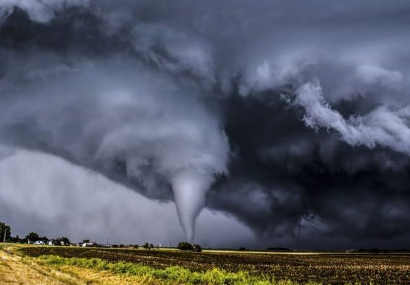
Step 5: A Funnel Forms and Touches Down
As pressure drops and moisture condenses, a visible funnel cloud may form beneath the storm base. If the circulation reaches the ground, it becomes a tornado. Sometimes the condensation funnel touches down clearly. Other times debris at the surface gives the first clue that tornado contact has already happened. So the textbook cone funnel is not required. Tornadoes are not obligated to be photogenic.
Why Supercells Matter So Much
Supercells are the celebrities of severe weather, although “celebrity” may be too flattering for a storm that can throw tractors around. A supercell is a thunderstorm with a deep, persistent rotating updraft. These storms are longer-lived, more organized, and more capable of producing large hail, destructive straight-line winds, flash flooding, and tornadoes.
Most of the strongest and longest-track tornadoes come from supercells because those storms are especially good at organizing spin and maintaining powerful updrafts. When a supercell develops a wall cloud, a lowered cloud base beneath the rotating updraft, forecasters and storm spotters pay close attention. A rotating wall cloud can be a warning sign, though it does not guarantee a tornado.
Do All Tornadoes Come From Supercells?
No. Most strong tornadoes are linked to supercells, but tornadoes can also form along squall lines and quasi-linear convective systems, or QLCS. These are long lines of thunderstorms that can produce brief tornadoes, sometimes embedded in heavy rain and harder to spot. Non-supercell tornadoes also exist, including some landspouts and waterspouts.
That said, the classic “big tornado” setup usually involves a supercell. If the atmosphere were a theater production, the supercell would be the lead actor, the mesocyclone would be the dramatic monologue, and the tornado would be the scene that everyone remembers forever.
Why Tornado Formation Is Still Hard to Predict
Here is the humbling part: meteorologists still do not fully understand why one rotating storm produces a tornado while another, in a similar environment, does not. Scientists know the major ingredients and have strong theories about the role of downdrafts, temperature contrasts, near-ground vorticity, and storm-scale interactions. But the exact final steps of tornadogenesis remain an active area of research.
That is why forecasting tornadoes happens on different levels. Meteorologists can often identify areas where tornadoes are possible hours in advance. Predicting the exact neighborhood, exact minute, and exact storm cell that will produce a tornado is much harder. Radar, storm reports, field campaigns, and high-resolution models have all improved warning performance, but tornadoes still keep part of their playbook hidden.
Where and When Tornadoes Most Often Form in the United States
The United States is one of the world’s biggest tornado hotspots because it regularly brings together the ingredients severe storms love most. Warm, moist Gulf air can surge northward, cooler dry air can arrive from the west or north, and strong upper-level winds can provide the wind shear needed for rotation. The central Plains are famous for this setup, which is why “Tornado Alley” became part of everyday weather language.
Still, that phrase can oversimplify reality. Tornado risk shifts through the year. In cooler months, the Southeast can be especially vulnerable. In late spring, the southern and central Plains tend to become more active. In early summer, the threat often shifts farther north into the Plains and Midwest. Tornadoes have been reported in all 50 states, which is the atmosphere’s way of reminding everyone not to get smug.
How Meteorologists Spot Tornado Danger
Watches vs. Warnings
A tornado watch means conditions are favorable for tornadoes. It is your cue to pay attention, review your shelter plan, and stay weather-aware. A tornado warning means a tornado has been sighted or indicated by radar. That is the moment to act, not to peer outside and conduct your own amateur documentary.
Radar Clues
Doppler radar helps meteorologists detect rotation within thunderstorms. Forecasters look for storm structures such as mesocyclones, hook echoes, and debris signatures. These radar tools do not eliminate uncertainty, but they are essential for identifying which storms need warnings right now.
The EF Scale
After a tornado, experts survey the damage and assign an EF rating from EF0 to EF5. This rating is based on estimated wind speeds inferred from what the tornado damaged and how badly it damaged it. That means the EF rating tells us how destructive the tornado was, not necessarily every detail of its internal wind field at every second.
Basic Tornado Safety That Actually Matters
If a tornado warning is issued, your safest shelter is a basement, storm cellar, or a small interior room on the lowest floor of a sturdy building, away from windows. Mobile homes are especially dangerous during tornadoes and should be left for sturdier shelter well before the storm arrives if possible.
It is also smart to have multiple ways to get warnings, including phone alerts, local media, and NOAA Weather Radio. Tornadoes do not always arrive with a picture-perfect funnel or plenty of daylight. Some are wrapped in rain. Some happen at night. Some give only minutes of lead time. Preparedness is not boring; it is the part of the story where you get to keep your roof.
Experiences Related to Tornado Formation: What It Feels Like When the Atmosphere Starts Building One
People who live in tornado-prone parts of the United States often say they can feel when the day has “that look.” That feeling is not magic, and it is not a sixth sense. It is usually the atmosphere advertising its ingredients. The air may be unusually warm and sticky, with a heaviness that seems to sit on your skin. Clouds may begin the day looking harmless, then start towering upward by afternoon, growing taller, darker, and more sharply defined. Meteorologists would describe that as instability and strong lift getting to work. Most people describe it as, “Well, this feels weird.” Both are fair.
As storms begin to organize, the experience can become stranger. Winds at ground level may pick up and flow steadily toward the storm, a sign of strong inflow feeding the updraft. Leaves can rustle in one constant direction. Flags stretch hard. The sky may develop dramatic texture, with bands of cloud appearing to feed into the storm from miles away. Under a supercell, some people notice a lowered, rotating area beneath the storm base called a wall cloud. It can look unsettlingly deliberate, as if the cloud has decided to stop improvising and start planning.
Storm chasers and trained observers often talk about how fast the atmosphere changes when tornado formation becomes more likely. A storm that seemed messy can suddenly look organized. Rain may wrap around one side of the circulation. Hail may begin falling. The wind can shift abruptly. In some cases, a rear-flank downdraft carves out a clear slot behind the wall cloud, visually tightening the storm’s low-level circulation. For the average person on the ground, that whole chain of events may simply feel like the sky has switched from threatening to urgent.
Then there is the sound. Survivors often compare it to a freight train, a roar, or a long mechanical growl. That description is useful, but it can also be misleading because not every tornado sounds the same and not every dangerous storm gives obvious audio clues. By the time the sound is memorable, it may already be too close for comfort. That is why meteorologists and emergency managers keep repeating the same advice: do not wait for visual drama before taking shelter. Tornadoes are under no legal obligation to look like the movie version.
There are also experiences after the fact that help people understand tornado formation more clearly. Residents often describe how sharply the damage path can begin and end. One house may be shattered while another nearby has only minor damage. Trees can be stripped on one side of the street while leaves remain on the other. That narrow, concentrated violence is a clue to what tornadoes really are: not just “strong wind,” but intensely focused rotation created inside a storm that has managed to organize energy into a much smaller and more destructive core.
For meteorologists, storm spotters, and everyday residents, these experiences reinforce the same lesson. Tornado formation is not random, but it is fast, complicated, and sometimes deceptive. The atmosphere lays out hints: the humidity, the towering clouds, the rotating storm base, the inflow, the strange lighting, the sudden urgency. But the safest response is never to stand outside collecting clues. Let radar, alerts, and forecasters do the detective work. Your job is simpler: know where to go, go there quickly, and leave the dramatic weather appreciation to people who are not currently in the path of a rotating column of airborne demolition.
Conclusion
So, how do tornadoes form? They form when a powerful thunderstorm, usually a supercell, develops in an environment with warm, moist air near the ground, cooler air above, a lifting trigger, and strong wind shear. That wind shear creates spin, the storm’s updraft tilts the spin upright, and complex interactions near the ground can tighten and intensify the rotation until a tornado develops. The broad science is well established. The final handoff from rotating storm to full tornado is still one of meteorology’s most stubborn puzzles.
That balance of knowledge and mystery is what makes tornadoes so captivating. We know enough to forecast danger zones, issue watches and warnings, detect storm rotation, and improve survival through preparation. But we are still learning exactly why one storm becomes a producer while another fizzles out. In the meantime, the smartest approach is equal parts curiosity and caution: appreciate the science, respect the warning system, and never underestimate a storm just because it has not dropped a funnel yet.