Table of Contents >> Show >> Hide
- What Was Found on Bray Head?
- Why Ireland Built Giant ÉIRE Signs During World War II
- Why This Discovery Captured So Much Attention
- The Bray Head Landmark as a Piece of Ireland’s Wartime Story
- What the Wildfire Changed, Beyond the View
- Specific Examples That Help Explain the Significance
- Why the Story Works So Well for Modern Readers
- The Case for Protecting Small, Strange, Easy-to-Miss Landmarks
- Experiences Related to “Wildfire Reveals WWII-Era Landmark in Ireland”
- SEO Tags
Sometimes history arrives with a trumpet fanfare. Sometimes it arrives after a wildfire burns away a stubborn layer of brush and says, in effect, “Surprise, I was here the whole time.” That is more or less what happened on Bray Head in County Wicklow, Ireland, when a blaze exposed the remains of a giant World War II-era ÉIRE marker hidden beneath vegetation for decades.
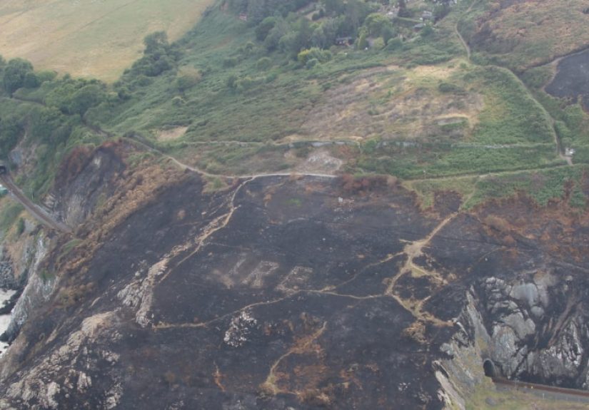
From the air, emergency crews surveying the scorched hillside spotted the faint but unmistakable outline of a stone message: ÉIRE, the Irish-language name for Ireland. The discovery was dramatic, but the sign itself was never meant to be mysterious. During World War II, these oversized ground markings were built to do one very practical job: tell pilots exactly where they were. In an era before cockpit screens chirped cheerful instructions like “recalculating,” giant letters made of stone were a fairly persuasive way to say, “You are over neutral Ireland. Please act accordingly.”
The wildfire did not create the landmark. It simply peeled back time. And in doing so, it reminded people that landscapes are not just scenery. They are archives. Hillsides remember. Coastlines keep receipts.
What Was Found on Bray Head?
The newly re-exposed landmark was an ÉIRE sign associated with wartime coastal defenses. Bray Head, a dramatic headland south of Dublin, sits in a part of Ireland where sea, wind, rock, and weather all have strong opinions. During the war years, that coastline mattered strategically. Ireland maintained neutrality, but neutrality still required vigilance, especially when aircraft and ships moved across nearby Atlantic and British waters.
The Bray Head marking was identified as No. 8, one of a network of numbered signs placed near coastal lookout posts. The numbers were not decorative flair. They made the markers more useful as location references from the air. To a pilot navigating uncertain skies, a numbered ground sign was part warning, part reassurance, part “you are here” map pin the size of a small ego.
For years, the Bray Head sign had effectively disappeared beneath gorse and undergrowth. Then fire swept over the landscape, blackened the vegetation, and suddenly the old stones stood out against the charred earth. It was a startling visual contrast: modern emergency response meeting wartime memory in a single aerial image.
Why Ireland Built Giant ÉIRE Signs During World War II
Ireland’s Neutrality Was Real, but It Was Not Passive
To understand why the sign matters, it helps to understand Ireland’s wartime position. During World War II, the Irish state remained officially neutral. In Ireland, the period is often referred to as “the Emergency,” a term that captures both the country’s non-belligerent status and the very real pressure of existing beside a continent at war.
Neutrality did not mean shrugging and hoping for the best. Ireland established a Coast Watching Service, building lookout posts around the coastline so observers could track aircraft and shipping activity. These posts served as an early-warning network, helping the government monitor what was happening around its shores. Historical records describe 83 lookout posts around the coast, each with a designated number. The ÉIRE signs were tied to this system and functioned as bold visual markers for aviators overhead.
The letters were usually formed with stones and often painted to stand out clearly. Their message was simple: this was Ireland, not Britain, and not a combat target. In a war where navigation errors could be fatal, a clear sign on the ground could prevent confusion, accidental overflight, forced landings, or worse.
A Message to Allied and Axis Pilots Alike
The signs are fascinating because they were both political and practical. Politically, they reinforced Irish neutrality. Practically, they helped pilots avoid dangerous mistakes. Historians have noted that the markers also became helpful navigational aids, especially for Allied crews flying routes shaped by weather, fuel limits, and wartime urgency.
That makes the Bray Head discovery more than a quirky “look what the fire found” story. It opens a window onto a moment when neutrality had to be written into the landscape itself. Ireland did not just declare a policy; in places like Bray Head, it spelled it out in giant letters.
Why This Discovery Captured So Much Attention
Part of the appeal is visual. There is something cinematic about a forgotten sign reappearing after decades, especially one tied to World War II. It sounds like the setup for a historical thriller, minus the dramatic violin score and the archeologist who somehow looks great in gale-force wind.
But the deeper reason this story resonated is that it combines several themes people find irresistible: wildfire, hidden history, wartime mystery, and aerial discovery. It also offers a rare example of a destructive event accidentally revealing something valuable. No one celebrates the fire itself, of course. Wildfires are dangerous, disruptive, and often devastating. Yet in this case, the aftermath allowed people to see a buried layer of local heritage that had slipped from public view.
The story also traveled well because it speaks to a larger truth about landscapes. Vegetation grows. Memory fades. Built features collapse, sink, or disappear into plain sight. Then a change in season, weather, or land use reveals what was always there. Archaeologists, historians, and conservationists see this pattern often. The Bray Head sign just happened to make the point in unusually large letters.
The Bray Head Landmark as a Piece of Ireland’s Wartime Story
Coastal Defense Without Grand Monuments
When many people imagine World War II landmarks, they picture bunkers, battlefields, airfields, or memorials in major capitals. Ireland’s ÉIRE signs tell a different story. They are modest in material but bold in scale. They do not commemorate victory. They do not glorify combat. Instead, they represent caution, observation, and the practical choreography of survival on the edge of war.
That is one reason they matter so much. They preserve the texture of everyday wartime reality in a neutral country. The sign on Bray Head was not built for ceremony. It was built for function. That functional design is exactly what gives it emotional power today. It feels direct, unsentimental, and very human: if planes are overhead, let’s give them information before something terrible happens.
The Numbering System Matters Too
Bray Head’s identification as ÉIRE 8 links it to the wider chain of lookout posts and signs around the coast. This is important because it turns the discovery from an isolated curiosity into part of a national wartime system. The sign was not random folk art on a hillside. It belonged to infrastructure, intelligence, and defense planning.
That network gives the Bray Head marker historical context and explains why similar signs elsewhere in Ireland have attracted restoration efforts. Once people understand that these markers formed a connected system, they stop looking like odd old letters on a hill and start reading as rare survivors of a strategic landscape.
What the Wildfire Changed, Beyond the View
Wildfire stripped away the camouflage of time. In practical terms, it made the stones visible again. In cultural terms, it restarted a conversation about preservation. Once a hidden feature becomes visible, people have choices to make. Should it be documented, protected, restored, interpreted for visitors, or left largely untouched? Each option involves trade-offs between authenticity, safety, access, and conservation.
That conversation is especially important in places like Bray Head, where natural beauty, recreation, weather exposure, and heritage value all collide. A rediscovered landmark can quickly shift from forgotten relic to fragile attraction. Visibility brings attention; attention brings risk. Foot traffic, souvenir-hunting, weathering, and amateur “improvements” can all damage a site faster than neglect sometimes does.
Still, rediscovery also creates opportunity. It invites local pride, educational programs, heritage mapping, and more serious public interest in Ireland’s lesser-known World War II sites. And that is one of the most valuable outcomes of the Bray Head wildfire story: it broadened the public’s sense of what counts as a wartime landmark.
Specific Examples That Help Explain the Significance
Bray Head is not the only place in Ireland connected to surviving ÉIRE signs. Other markers have been identified, documented, and in some cases restored in coastal locations across the country. These examples show that the Bray Head discovery belongs to a wider story of remembrance and preservation rather than a one-off accident.
Some restored signs make it easier to imagine how striking the original system must have looked from the air. Clean white stones, large block letters, open coastal ground, and a numbered post nearby would have created an unmistakable signal for pilots. Even today, restored examples help modern visitors understand how wartime navigation could rely on terrain, sightlines, and human ingenuity rather than digital instruments.
Bray Head, however, carries a special kind of drama because it was not neatly preserved in plain sight. It had to be rediscovered. That gives the site a layered meaning: it is both an original wartime object and a modern lesson in how easily history can disappear under something as ordinary as shrubs.
Why the Story Works So Well for Modern Readers
There is also a psychological reason this story lingers. In the digital age, people are used to the idea that everything is searchable. Need a restaurant? Search it. Need a train time? Search it. Need a forgotten wartime hillside message? Apparently, wait for a wildfire and hope history has good timing.
The Bray Head sign pushes back against the illusion that the past is always neatly cataloged and instantly accessible. It reminds us that some history is still embedded in landforms, hidden by seasons, and dependent on chance. That makes the rediscovery feel almost intimate. The earth kept a secret, and one difficult summer finally brought it back into view.
It also encourages a more generous view of “ordinary” places. A hill path, a windy overlook, a scorched patch of ground, a string of coastal stones: none of that sounds spectacular until context arrives. Then suddenly the same hillside becomes a surviving message from the 1940s, written for pilots crossing a nervous sky.
The Case for Protecting Small, Strange, Easy-to-Miss Landmarks
Big monuments usually get the brochures. Small infrastructure often gets forgotten. Yet humble structures can reveal far more about how people actually lived through crisis. The Bray Head sign belongs to that category. It is not grand in the traditional sense, but it tells a rich story about wartime geography, Irish statecraft, civilian vigilance, and the physical language of neutrality.
Protecting places like this matters because they connect policy to place. “Ireland was neutral during World War II” is a historical statement. ÉIRE 8 on a burned hillside is the physical evidence that neutrality had to be managed, signaled, and defended in real time.
That is the larger lesson of the wildfire reveal. Heritage is not only found in castles, cathedrals, and museum cases. Sometimes it survives in stone letters on a cliff, waiting out decades of weather and weeds until one dramatic event forces us to look down and notice what the ground has been saying all along.
Experiences Related to “Wildfire Reveals WWII-Era Landmark in Ireland”
There is something unforgettable about encountering a place where natural force and human history overlap so visibly. Even if you never stand on Bray Head yourself, the scene is easy to imagine: a coastal slope darkened by fire, sea air rolling in, and a wartime message suddenly legible again after generations of silence. It is the kind of discovery that changes the mood of a landscape. What looked like empty ground becomes a document.
For hikers, local residents, and history lovers, experiences like this tend to unfold in layers. First comes surprise. Then curiosity. Then that delightful little mental jolt when the scale of the thing clicks into place. These were not tiny stones arranged for fun on a Saturday afternoon. They were large enough to speak to pilots in the sky. Standing near such a marker, a person can feel the gap between wartime urgency and present-day calm collapse in an instant.
There is also a sensory side to the experience. Coastal heritage sites in Ireland are rarely tidy or theatrical. They are windy, exposed, damp, rocky, and gloriously uninterested in your hairstyle. That roughness matters. It helps explain why the ÉIRE signs feel so grounded in real history. They are not polished exhibits under perfect lighting. They are embedded in weather, salt, slope, and silence.
People who visit places connected to the Coast Watching Service often describe a sharpened awareness of distance. You look out to sea and begin to understand why lookout posts were built where they were. You notice the horizon differently. You imagine observers scanning sky and water for unfamiliar aircraft or vessels. The experience is not loud, but it can be deeply atmospheric. The land itself seems to hold posture, as if still on watch.
Wildfire adds another emotional layer. Burned landscapes can feel unsettling, even when new growth is already beginning. Blackened ground has a way of making time visible. In Bray Head’s case, the fire did something eerie and almost accidental: it made the modern landscape look briefly closer to its wartime form by removing what had accumulated later. That kind of reveal can feel uncanny, like opening a drawer in a familiar house and finding a letter from another century.
For communities, discoveries like this often spark a mix of pride and responsibility. Pride, because a place long overlooked suddenly matters to a national and even international audience. Responsibility, because once people know a landmark exists, they have to decide how it should be treated. Do they restore it? Fence it? Signpost it? Leave it mostly alone? Those questions become part of the experience too, especially for locals who live with the site after the headlines fade.
Teachers and parents may find another kind of value here. Stories like Bray Head’s make history easier to grasp because they are so physical. A student may forget a paragraph about neutrality in a textbook, but a giant ground sign exposed by fire is much harder to forget. It turns abstraction into image. Suddenly World War II is not just dates and treaties. It is a hillside message intended for aircraft that might otherwise mistake one country for another.
There is a tourism lesson in this as well. Not every meaningful travel experience comes from famous landmarks with gift shops and long lines. Sometimes the most memorable places are the ones that require context to appreciate. A cliff path, a ruin, a lookout, a weathered sign: these places ask for imagination. They reward slower attention. And when visitors understand the story, the experience can feel richer than many more polished attractions.
In the end, the strongest experience tied to the Bray Head discovery may be a renewed sense of humility. Landscapes are older, smarter, and more layered than they first appear. Fire, though destructive, can occasionally expose truths that comfort and routine have hidden. A person reads about a wildfire revealing a WWII-era landmark in Ireland and expects a curious news item. What they get instead is a reminder that history is still underfoot, still vulnerable, and still capable of surprising us when the ground finally decides to speak up.